Giant images of the Nazca Valley: Communication with a deity or signals to space ships?
 Civilizations left in the past have left riddles to modern man, on the solution of which the best minds of historians and archaeologists are thrown. A number of riddles have an explanation, but some remain a mystery throughout the centuries, which scientists cannot explain. One such mystery was the giant drawings in the Nazca Valley in South America.
Geoglyphs
The Nazca Plateau is located in the southern part of Peru and covers an area of approximately 7 kilometers by 50 kilometers. For a long time, local residents paid attention to the lanes stretching along the valley for tens of meters, considering that they were made to help the travelers with orientation. Some of the bands were straight, some had a different form – one way or another, until humanity invented air transport, nobody could look at the patterns entirely.
When, in 1939, the strip was seen by an American archeologist, Paul Kosok, the world was astonished: a variety of figures were drawn on the plateau, both geometric and depicting animals, plants and people.
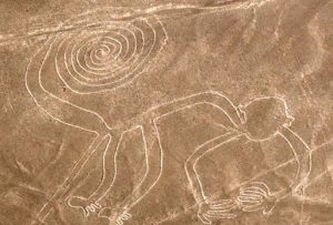
On the plateau there are 30 patterns – images of humans, plants and animals, 700 geometric figures – mainly triangles and trapeziums, as well as 100 spirals and about 13 thousand straight lines. All of them were created no later than the 8th century AD and can be recognized and seen only from the air.
The dry climate allowed the lines to remain unchanged for centuries – trenches that exposed light gravel under the dark surface of the local semi-desert soil retained their shape until our days.
Most of the lines are perfectly straight grooves that go through hills, dried riverbeds, without the slightest deviation from the straight. The width of the furrow reaches 135 centimeters, and the depth is 50, the average depth is about 30 cm. The length of the lines is from 50 to 190 meters.
The patterns applied to the earth, geoglyphs, pose a large number of questions to the researchers – by whom they are applied, how, when and why?
History of the Nazca lines
The Nazagan geoglyphs were reported back in 1553 by the Spanish traveler, geographer and priest Pedro Cieza de Leon. He considered them signs to determine the path.
The study of the lines began Maria Reiche, an archaeologist who learned about the existence of geoglyphs from Paul Kosok. From 1941, for several decades, Reiche explored the Nazca Plateau, manually measuring more than 700 figures and mapping patterns and images. Among the drawings were found “monkey”, “hummingbird”, “spider”, as well as a figure called the “astronaut” – about 30 meters in length.
A surprising coincidence – one of the geoglyphs depicts hands, and on one of them there are five fingers, and on the other – four. Maria Reiche was missing one finger on his left hand.
In the process of studying the phenomenon of Nazca geoglyphs, researchers now and then encounter hard-to-explain facts. For example, the fact that near the lines there are no traces of their creators, paths, evidence of the use of tools. In connection with this, a version is expressed that they were scratched from the air by some special object resembling a giant pencil.
Currently, large-scale studies of Nazca geoglyphs are not carried out due to material reasons – the Peruvian authorities do not finance the work. On the territory of the plateau to preserve the ancient patterns created reserve.
Versions
Maria Reiche assumed that the goal pursued by the outline of multimeter patterns on the plateau was astronomical (as well as astrological) predictions. The ancients could determine the position of the sun, the stars along the lines and thus keep a calendar. Currently, the version of the astronomical purpose of lines and patterns is disputed by scientists.
A certain oddity is also represented by the fact that the attention of the German researcher turned out to be completely deprived of the neighboring Palpa Plateau – located 20 kilometers north of Nazca. Meanwhile, this territory also contains many drawings on the surface of the earth, and, unlike the Nazca images, it can boast not one “little man”, but a whole dozen.
In one, scientists agree – the lines were created before the arrival of the Inca civilization on these lands, that is, before the 8th century, and most likely the creation of geoglyphs is the result of the activities of the Nazca civilization that had disappeared, which existed before the 6th century AD
Whether the unknown creators of the patterns addressed their deities, or communicated with some extraterrestrial civilization, new generations of scientists are to find out. Among them is Victoria Nikitsky, former assistant Maria Reiche, who continues to work on the Nazca geoglyphs.
Other ancient civilizations have left behind a lot of unexplained archaeological finds, which scientists of the whole world are fighting to explain.